A Cultural Expedition To Noordhoek To Observe Complete Strangers Making Maps
Warning: This post is picture intensive.

I know you're wondering why we are going to all this effort to make maps. The reason, of course, is because we don't have maps in South Africa, as the pretty (inane) Miss (Teen) South Carolina unabashedly informed the world recently. We're all quite ashamed so we've quietly been trying to rectify the situation via a project called OpenStreetMap.
For our first mapping party (I'm not sure why they called it a party because there weren't any hats) we chose to map Noordhoek. Noordhoek is a suburb in Cape Town that few people live in and even fewer have heard of so it was perfect because if we made a mistake no one would ever know.

So, where can a group of random strangers meet to start mapping Noordhoek without it seeming creepy? The answer: Noordhoek Farm Village, which has a bunch of scary scarecrows out front (not pictured, for your sanity) and a TEARS Pet Day extravaganza at the back that happened to coincide with the one day that we decided to map Noordhoek in the one place we thought would be a quiet, crowdless spot to spot random strangers who were trying to congregate to make maps. Much hilarity ensued!

These are volunteer fire people, who were congregating at Noordhoek Farm Village. They have nothing to do with mapping, except they may need maps if you're on fire and they can't find you.

This is Adrian from OSM, who likes to map Cape Town. Don't confuse him with the other Adrian from OSM who likes to map Cape Town. He wasn't here. This is the Adrian that was here. Adrian is holding a printout of the map that we were going to map. We were all a bit confused because the page was almost completely blank but then Russell, who printed it out, explained that it was blank because we hadn't mapped it yet. Then we understood.
There were five of us so we decided to split into two teams, because five is easily divisible by two. I was given the option of choosing either team, so I opted for Team Two. (I just named it Team Two because there were three of us so that seemed apt.) We each had a car, a camera, and a GPS device, and we split up and drove to opposite ends of Noordhoek to start the mapping process. This way we could compile overlapping data, which is more accurate when you eventually draw the maps.
Or something. I'm just saying all that stuff so that it looks like I learnt something while out observing random strangers make maps and wasn't just taking photos for my own idle amusement.

This is a Stop sign. Although, technically, a sign, it's not a sign you can map, except you probably could, but you wouldn't necessarily want to, unless you were into that kind of thing, and who says you shouldn't be? I don't really know about deviant mapping behaviour. Anyway, in this case it just snuck into my shot unexpectedly, like those random people you see on TV waving at the camera behind a Very Serious news reporter who's talking about consumer price index fluctuations and how they are going to affect the man on the street (who is behind, waving, unaware that they are affecting him). It's a vicious circle.

This is a Bent sign. I've started classifying them, since I'm now a sign expert.
It's also a Camouflaged sign and a Shaded sign and a Leaning sign.

This is the way to Chapman's Peak, which is closed more than it's open. All those signs but nothing to map. What a disappointment.

This is someone's house, up a private driveway that we "accidentally" drove along. You won't find the road on the final map because we thought we'd respect the owners' privacy by only posting the photos we took.

Shhh! I am camouflaged in the back of a silver Open Corsa 1.6 Elegance observing two lesser Spotted Mapping Geeks of the male persuasion. They all use Ubuntu Linux and say words such as "fractal" and "load sharing".

On this road all the good stuff's only in one direction, unless you're coming from that direction, in which case it's in the opposite direction. But as long as you can find these signs, you won't be lost. We didn't map these signs either, though, so you'll have to look for them yourself. I promise they're there, because this is the photographic proof.

"What the hell is a 'Stg'?," you may be wondering. We spent most of the trip wondering the same thing. It's a shortening of an Afrikaans word for, er, something. I don't know. I only speak English. If you can find this road sign and look at the other side of it, you can find the answer. Most of the Noordhoek road signs are multilingual. It's a public service for multilingual people.

Recognise these? After I saw Nassau and Leerdam I got very excited, to the bewilderment of the Zimbabwean and the Durbanite in the car. I explained that those were the names of two of the points of The Castle. Then I had to explain what The Castle was. Anyway, I was really excited for us to find Oranje until someone pointed out that we had already. Turns out that was true - I had even photographed it - twice - at which point I must have immediately forgotten about it... twice.... I'm not sure what that was about. It could be that my memory

Yeah. Get out the damn way, I say! There is important mapping in progress and you're putting a kink in our GPS trail!

We found a section with roads with no names, and no houses. It was eerie, like the buildings had been sucked out of our universe by some sort of nefarious entity one evening while we were all sleeping.
There was also a stream.

Noordhoek is an exclusive suburb for the rich and idle. They have dogs that hover and tiny, tiny horses for short, thin people. You have to drive slowly just to marvel at all the miraculous wonders (not seen here).
You should have heard the Zimbabwean and the Durbanite try to pronounce "Katzenellenbogen". I had to do it for them. I didn't know how to operate the GPS device but I had my uses.

Mapping isn't just about mapping, it's also about art. This was my hard-won artistic shot for the day. I actually had to hold my camera out the moving car's window to get this shot. What you can't see, though, is the tree that's placed artistically in the middle of the road. Unfortunately there's a moving car in the way of my shot.

The road signs get fancier in the more upmarket parts of the suburb. That roof is made of thatch, which is the kind of roof you don't want when the roaring Cape Town fires sweep through your suburb, much like the Great Noordhoek Fire of 1999 did. What a spectacle that was! We were all glad we didn't live there.
I think it's for homes such as these that Noordhoek has volunteer fire people in bright-yellow jackets. At least now they'll have free maps to guide them to your house when it's on fire, unlike in 1999, when they didn't have maps at all.

Here's that tree that I was telling you about that's in the middle of that road. I know you thought that I was making it up, so here's proof, from a different angle. The angle is different because we drove around a lot at different angles.

I know, you're going, "Huh?" There's a road sign there - I marked it for you in red. I had to use up my quota of red circle graphics on something.

As part of our mapping endeavour we discovered a really startling fact: in Noordhoek there are at least two establishments (surprisingly within driving distance of each other) called "The Dunes". I presume that's because they're built on dunes or there are dunes on the beach, or something. Not that you can see any dunes, or even the beach, from either of the establishments named after them. Noordhoek people are weird. It must be all the sea air.

A little glimpse of the beach, with the dunes that no one can see, just to prove that it is there (in case you were wondering), although I still don't know about the mysterious dunes that everyone is naming everything after.

This is my favourite road sign. I think it says "Acacia St(reet)" but I like to make up my own names for it. There's no one to tell me I'm wrong, since I'm one of the ones making the maps.

How poplar* is this road? Well it's shaped like a rectangle and each corner has a sign with a different name on it. There were two rectangular roads like this, right next to each other. I guess they had too many names and didn't know what else to do with them. I would have donated them to a worthy cause, but that's just me. I have a charitable conscience.

This sign was trying to camouflage itself in a bush, but that's like trying to hide a giraffe in a car with a sunroof.
Or a bad metaphor in a good simile.

Just in case you can't read all the signs fast enough as you're zipping by in your cabriolet on the way to the beach they put up more signs so you'd be able to read some signs in time, just in case you couldn't.

Go here for food and rest.
There aren't any monkeys. It's very disappointing.

The dark, ominous tunnel. I'm very fond of tunnels so I persuaded my companions to follow the road to see where it went. Turns out it's the world's longest driveway. At one point it even has its own view. Anyway, we left it off the final map because it's someone's private entrance and you really shouldn't spend time in other people's private entrances without first getting their permission.

When you drive uphill the GPS device has a tendency to slide off the dashboard. It's a simple lesson in physics that I think will come in handy next time I'm tempted to place something on my own dashboard (not seen here). Who said you can't learn anything useful while out mapping obscure places?

This is how professional mappers park when they've had enough and want food. An hour of driving around backwards and in circles is exhausting, I tell you!
Well, actually, I don't know that for sure because I wasn't driving.

This is what a bunch of mappers look like when they're inputting data. You can't see me because I'm behind the camera.

This is data.

This is what a bunch of mappers look like when they're inputting data from a different angle. You can't see me here either because I'm still behind the camera. In fact, it's almost as if I wasn't there, which is probably why they hid me in the back of the second car.

This is also data. It's a hard-copy backup that's a spectacular on-the-fly amalgamation of the GPS data and the camera data. It's always important to have hard-copy backups (and one should store them in a second location, such as in your pocket).
That's not my arm, in case you were wondering.

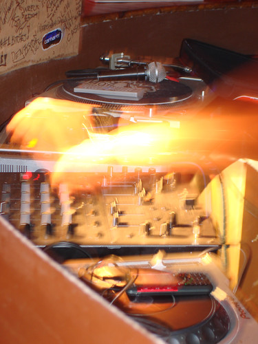
This is the software into which we input our data. And by "we" I mean not me, because by this point I was confused and, anyway, I don't have a laptop. The laptop was running Ubuntu Linux, of course, which was very brotherly and in the spirit of random Africans converging to map things.
For the next hour we ate, drank, and inputted data, which is really the hard part when it comes to making free maps. This laborious task of tracing GPS data trails to draw streets, and then inputting street and notable-landmark information, is not for the faint hearted and takes much dedication. Next time you're using a free map for commercial purposes, remember the individuals who loving put all the data together, at their own time and expense, for your profit. It's what capitalism is all about!
Anyway, if you click here and zoom in you can see the data that was added as a result of this mapping party. Monkey Valley is not on the map but that's ok - you've seen the signs so you know where it is. That's my contribution to the collective endeavour.

After that I drove home. This guy was in the way a lot. I got annoyed.
*One terribly awful "pun" only, I promise.
I know you're wondering why we are going to all this effort to make maps. The reason, of course, is because we don't have maps in South Africa, as the pretty (inane) Miss (Teen) South Carolina unabashedly informed the world recently. We're all quite ashamed so we've quietly been trying to rectify the situation via a project called OpenStreetMap.
For our first mapping party (I'm not sure why they called it a party because there weren't any hats) we chose to map Noordhoek. Noordhoek is a suburb in Cape Town that few people live in and even fewer have heard of so it was perfect because if we made a mistake no one would ever know.
So, where can a group of random strangers meet to start mapping Noordhoek without it seeming creepy? The answer: Noordhoek Farm Village, which has a bunch of scary scarecrows out front (not pictured, for your sanity) and a TEARS Pet Day extravaganza at the back that happened to coincide with the one day that we decided to map Noordhoek in the one place we thought would be a quiet, crowdless spot to spot random strangers who were trying to congregate to make maps. Much hilarity ensued!
These are volunteer fire people, who were congregating at Noordhoek Farm Village. They have nothing to do with mapping, except they may need maps if you're on fire and they can't find you.
This is Adrian from OSM, who likes to map Cape Town. Don't confuse him with the other Adrian from OSM who likes to map Cape Town. He wasn't here. This is the Adrian that was here. Adrian is holding a printout of the map that we were going to map. We were all a bit confused because the page was almost completely blank but then Russell, who printed it out, explained that it was blank because we hadn't mapped it yet. Then we understood.
There were five of us so we decided to split into two teams, because five is easily divisible by two. I was given the option of choosing either team, so I opted for Team Two. (I just named it Team Two because there were three of us so that seemed apt.) We each had a car, a camera, and a GPS device, and we split up and drove to opposite ends of Noordhoek to start the mapping process. This way we could compile overlapping data, which is more accurate when you eventually draw the maps.
Or something. I'm just saying all that stuff so that it looks like I learnt something while out observing random strangers make maps and wasn't just taking photos for my own idle amusement.
This is a Stop sign. Although, technically, a sign, it's not a sign you can map, except you probably could, but you wouldn't necessarily want to, unless you were into that kind of thing, and who says you shouldn't be? I don't really know about deviant mapping behaviour. Anyway, in this case it just snuck into my shot unexpectedly, like those random people you see on TV waving at the camera behind a Very Serious news reporter who's talking about consumer price index fluctuations and how they are going to affect the man on the street (who is behind, waving, unaware that they are affecting him). It's a vicious circle.
This is a Bent sign. I've started classifying them, since I'm now a sign expert.
It's also a Camouflaged sign and a Shaded sign and a Leaning sign.
This is the way to Chapman's Peak, which is closed more than it's open. All those signs but nothing to map. What a disappointment.
This is someone's house, up a private driveway that we "accidentally" drove along. You won't find the road on the final map because we thought we'd respect the owners' privacy by only posting the photos we took.
Shhh! I am camouflaged in the back of a silver Open Corsa 1.6 Elegance observing two lesser Spotted Mapping Geeks of the male persuasion. They all use Ubuntu Linux and say words such as "fractal" and "load sharing".
On this road all the good stuff's only in one direction, unless you're coming from that direction, in which case it's in the opposite direction. But as long as you can find these signs, you won't be lost. We didn't map these signs either, though, so you'll have to look for them yourself. I promise they're there, because this is the photographic proof.
"What the hell is a 'Stg'?," you may be wondering. We spent most of the trip wondering the same thing. It's a shortening of an Afrikaans word for, er, something. I don't know. I only speak English. If you can find this road sign and look at the other side of it, you can find the answer. Most of the Noordhoek road signs are multilingual. It's a public service for multilingual people.
Recognise these? After I saw Nassau and Leerdam I got very excited, to the bewilderment of the Zimbabwean and the Durbanite in the car. I explained that those were the names of two of the points of The Castle. Then I had to explain what The Castle was. Anyway, I was really excited for us to find Oranje until someone pointed out that we had already. Turns out that was true - I had even photographed it - twice - at which point I must have immediately forgotten about it... twice.... I'm not sure what that was about. It could be that my memory
Yeah. Get out the damn way, I say! There is important mapping in progress and you're putting a kink in our GPS trail!
We found a section with roads with no names, and no houses. It was eerie, like the buildings had been sucked out of our universe by some sort of nefarious entity one evening while we were all sleeping.
There was also a stream.
Noordhoek is an exclusive suburb for the rich and idle. They have dogs that hover and tiny, tiny horses for short, thin people. You have to drive slowly just to marvel at all the miraculous wonders (not seen here).
You should have heard the Zimbabwean and the Durbanite try to pronounce "Katzenellenbogen". I had to do it for them. I didn't know how to operate the GPS device but I had my uses.
Mapping isn't just about mapping, it's also about art. This was my hard-won artistic shot for the day. I actually had to hold my camera out the moving car's window to get this shot. What you can't see, though, is the tree that's placed artistically in the middle of the road. Unfortunately there's a moving car in the way of my shot.
The road signs get fancier in the more upmarket parts of the suburb. That roof is made of thatch, which is the kind of roof you don't want when the roaring Cape Town fires sweep through your suburb, much like the Great Noordhoek Fire of 1999 did. What a spectacle that was! We were all glad we didn't live there.
I think it's for homes such as these that Noordhoek has volunteer fire people in bright-yellow jackets. At least now they'll have free maps to guide them to your house when it's on fire, unlike in 1999, when they didn't have maps at all.
Here's that tree that I was telling you about that's in the middle of that road. I know you thought that I was making it up, so here's proof, from a different angle. The angle is different because we drove around a lot at different angles.
I know, you're going, "Huh?" There's a road sign there - I marked it for you in red. I had to use up my quota of red circle graphics on something.
As part of our mapping endeavour we discovered a really startling fact: in Noordhoek there are at least two establishments (surprisingly within driving distance of each other) called "The Dunes". I presume that's because they're built on dunes or there are dunes on the beach, or something. Not that you can see any dunes, or even the beach, from either of the establishments named after them. Noordhoek people are weird. It must be all the sea air.
A little glimpse of the beach, with the dunes that no one can see, just to prove that it is there (in case you were wondering), although I still don't know about the mysterious dunes that everyone is naming everything after.
This is my favourite road sign. I think it says "Acacia St(reet)" but I like to make up my own names for it. There's no one to tell me I'm wrong, since I'm one of the ones making the maps.
How poplar* is this road? Well it's shaped like a rectangle and each corner has a sign with a different name on it. There were two rectangular roads like this, right next to each other. I guess they had too many names and didn't know what else to do with them. I would have donated them to a worthy cause, but that's just me. I have a charitable conscience.
This sign was trying to camouflage itself in a bush, but that's like trying to hide a giraffe in a car with a sunroof.
Or a bad metaphor in a good simile.
Just in case you can't read all the signs fast enough as you're zipping by in your cabriolet on the way to the beach they put up more signs so you'd be able to read some signs in time, just in case you couldn't.
Go here for food and rest.
There aren't any monkeys. It's very disappointing.
The dark, ominous tunnel. I'm very fond of tunnels so I persuaded my companions to follow the road to see where it went. Turns out it's the world's longest driveway. At one point it even has its own view. Anyway, we left it off the final map because it's someone's private entrance and you really shouldn't spend time in other people's private entrances without first getting their permission.
When you drive uphill the GPS device has a tendency to slide off the dashboard. It's a simple lesson in physics that I think will come in handy next time I'm tempted to place something on my own dashboard (not seen here). Who said you can't learn anything useful while out mapping obscure places?
This is how professional mappers park when they've had enough and want food. An hour of driving around backwards and in circles is exhausting, I tell you!
Well, actually, I don't know that for sure because I wasn't driving.
This is what a bunch of mappers look like when they're inputting data. You can't see me because I'm behind the camera.
This is data.
This is what a bunch of mappers look like when they're inputting data from a different angle. You can't see me here either because I'm still behind the camera. In fact, it's almost as if I wasn't there, which is probably why they hid me in the back of the second car.
This is also data. It's a hard-copy backup that's a spectacular on-the-fly amalgamation of the GPS data and the camera data. It's always important to have hard-copy backups (and one should store them in a second location, such as in your pocket).
That's not my arm, in case you were wondering.
This is the software into which we input our data. And by "we" I mean not me, because by this point I was confused and, anyway, I don't have a laptop. The laptop was running Ubuntu Linux, of course, which was very brotherly and in the spirit of random Africans converging to map things.
For the next hour we ate, drank, and inputted data, which is really the hard part when it comes to making free maps. This laborious task of tracing GPS data trails to draw streets, and then inputting street and notable-landmark information, is not for the faint hearted and takes much dedication. Next time you're using a free map for commercial purposes, remember the individuals who loving put all the data together, at their own time and expense, for your profit. It's what capitalism is all about!
Anyway, if you click here and zoom in you can see the data that was added as a result of this mapping party. Monkey Valley is not on the map but that's ok - you've seen the signs so you know where it is. That's my contribution to the collective endeavour.
After that I drove home. This guy was in the way a lot. I got annoyed.
*One terribly awful "pun" only, I promise.
Labels: Cape Town, Cultural Expedition
posted by Mandy J Watson at 6:11 PM
Permanent link |
4 comments (add your own)
| ![]()
![]()